Multimodal redundancy identifies whether a network provides parallel routes for all travel modes. Higher redundancy provides more resiliency to operational issues (e.g., construction, traffic congestion, collisions, and traffic and weather incidents) and natural disasters.
| PERFORMANCE MEASURE | PERFORMANCE METRICS | PROJECT TASKS | APPROPRIATE CONTEXTS |
|---|---|---|---|
| Multimodal Redundancy | Percent of corridor segments lacking a connecting and parallel network (by mode: roadway, pedestrian, bicycle, transit) | Manage Assets Identify Needs Assess Alternative Strategies Refine Solutions Assign Resources Develop Funded Solutions | Urban Core Town/Urban Suburban Rural* |
| *sometimes applicable, refer to metric description for more information | |||
- What? Measures the percentage of corridor segments that lack a connecting and parallel network by mode, including driving, pedestrian, bicyclist, and transit modes.
- Why? Construction, traffic congestion, collisions, and traffic and weather incidents can block travel routes for people using all travel modes. The presence of connecting, parallel routes and the availability of complete connections via multiple modes allows the network to be resilient to these conditions and provides for a more reliable trip.
- Where? This metric is most relevant for corridor studies in urban core, town/urban, and suburban contexts. Evaluate modes that are present under existing conditions or that would be provided under project alternatives. Should also assess existing single access routes typically found in rural areas. Examples include SR 110 and SR 112, both on the Olympic Peninsula, where the state highway is the only way in and out of the area.
- How? Analyze in Cube Access by evaluating the access changes resulting from eliminating routes. Alternatively, GIS programs can be used to map alternative connecting and parallel routes and services for each mode. A more detailed network analysis will typically be required to understand the capacity of parallel/alternate routes for urban areas. Also analyze natural disaster risk data (e.g., flooding, landslides) to identify areas where more transportation network redundancy is needed.
| METRIC | SOURCES | DATA | ANALYSIS SOFTWARE | CALCULATION | RESOURCES |
|---|---|---|---|---|---|
| Percent of corridor segments lacking a connecting and parallel network | Roadway network shapefiles Project-specific data | Roadway network shapefile Pedestrian and bicycle network shapefile Transit network shapefile and service levels | Sugar Access GIS programs | Corridor segments without parallel network/corridor segments | Sugar Access GIS programs |
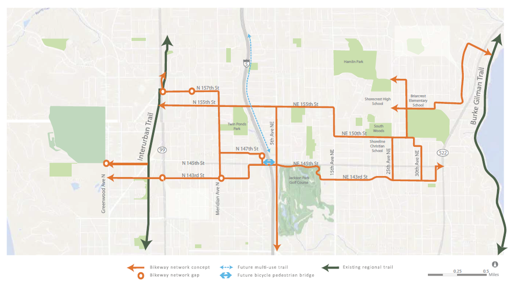
Case Study: Shoreline, WA 145th Street Multimodal Corridor Study (2016)
The percent of corridor segments lacking a connecting and parallel network can be used in corridor studies to understand network gaps for all modes of transportation. In the City of Shoreline’s 145th Street Multimodal Corridor Study (2016), the bike network that connects and runs parallel to the corridor was evaluated to understand bike opportunities that relate to the study. The map below shows parallel and connecting networks.