WSDOT has emphasized system efficiency in its management of travel on state highways. Throughput is one of the most important aspects of this system efficiency goal. Throughput can be measured as the number of vehicles, people or goods that can pass through a specific point within a defined time period. This measure considers throughput for vehicles, people, and freight moved by motor vehicle.
| PERFORMANCE MEASURE | PERFORMANCE METRICS | PROJECT TASKS | APPROPRIATE CONTEXTS |
|---|---|---|---|
| Throughput | Vehicle throughput | Identify Needs Assess Alternative Strategies Refine Solutions Assign Resources | Urban Core Town/Urban Suburban Rural |
| Person throughput | Identify Needs Assess Alternative Strategies Refine Solutions Assign Resources | Urban Core Town/Urban Suburban Rural* |
|
| Freight throughput | Assess Alternative Strategies Refine Solutions | Urban Core* Town/Urban* Suburban* Rural* |
|
| *sometimes applicable, refer to metric description for more information | |||
- What? Throughput of vehicles along a designated length of a highway or corridor.
- Why? Higher vehicle throughput means that the facility is maximizing the geometric capacity of the highway. This is not the same thing as maximizing the capacity of the highway to move people, which is addressed by the Person throughput
- Where? This metric is important throughout the state, considering vehicle flow through congested corridors in urban and suburban areas and ‘farm-to-market’ goods movement in both urban and rural areas.
- How? Measure the number of vehicles passing specific points within a corridor. WSDOT uses maximum throughput speed (the speed at which the largest number of vehicles can pass through a roadway segment) as the baseline speed for congestion and capacity performance measurement on highways. Maximum throughput is achieved on highways when vehicles travel at 70% to 85% of the posted speed limit (42 to 51 mph for a 60 mph speed limit). At maximum throughput speed, vehicles can travel closer together than they can at posted speeds, allowing more vehicles to pass through a segment. Note that vehicle miles traveled on a corridor can be evaluated by multiplying vehicle throughput by corridor length.
| METRIC | SOURCES | DATA | ANALYSIS SOFTWARE | CALCULATION | RESOURCES |
|---|---|---|---|---|---|
| Vehicle throughput | WSDOT average daily traffic counts and HPMS data Calibrated traffic model to estimate future vehicle travel demand | Vehicle counts Forecasted volumes Roadway network shapefile for mileage | GIS program Travel demand model | Multiply vehicle volumes by centerline miles | Washington Geospatial Open Data Portal |
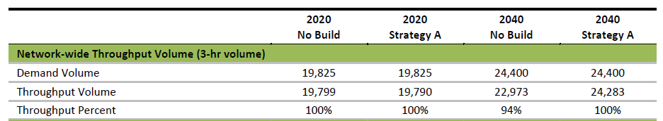
Case Study: SR 161 / 31st Avenue SW Corridor Study (2018)
Vehicle throughput can be evaluated using WSDOT average daily traffic counts Calibrated traffic models can help to estimate future vehicle travel demand and VMT in addition to vehicle throughput. Data can also be collected on a per project basis. The SR 161 / 31st Avenue SW Corridor Study measured the number of vehicles that travel through the study area during the three-hour analysis period. A throughput of less than 100 percent indicates there is still congestion at the end of the three-hour analysis period.
To learn more, visit the project website for the SR 161 / 31st Avenue SW Corridor Study.
- What? Throughput of persons along a highway or corridor.
- Why? Person throughput accounts for the benefits of vehicles that carry a higher number of persons, such as buses or carpools/vanpools. More persons per vehicle result in a more efficient throughput of persons through a length of corridor.
- Where? This is important throughout the state, primarily considering the flow of people in vehicles through congested corridors in both urban and rural areas.
- How? Measure the number of persons passing specific points within a corridor. While person volumes can be directly measured with counts, person throughput is typically calculated by multiplying the vehicle throughput by the number of persons per vehicle within a corridor, as measured by the Person occupancy metric). In urban areas, calculations are typically performed separately for general traffic and for transit then added together. Note that person miles traveled on a corridor can be evaluated by multiplying person throughput by corridor length.
| METRIC | SOURCES | DATA | ANALYSIS SOFTWARE | CALCULATION | RESOURCES |
|---|---|---|---|---|---|
| Person throughput | Historical count data by person Travel survey data on mode choice Calibrated travel model to estimate future person throughput | Vehicle volumes Vehicle occupancy Roadway network shapefile mileage | GIS program Travel demand model | Multiply vehicle volumes by centerline miles Multiply by average vehicle occupancy (can stratify separately by mode) |
There were no case studies identified for this metric.
- What? The number of trucks through a corridor, a measurement of freight traffic. Utilization of roadways and throughput can be measured in ton miles. An estimate total ton miles of freight movement in the corridor can help to understand freight flow along a corridor.
- Why? Estimated total freight throughput can increase our understanding of the movement of goods through specific corridors, or across the state.
- Where? This metric will be useful in cases where freight movement is a goal of the project, or an intention for the corridor. Generally, this metric will be relevant for analysis at the statewide level or when comparing different freight corridors.
- How? Estimate the number of trucks moved through a corridor. If possible, analyze the type of vehicle and other available information about size, load, etc. While freight ton miles has commonly been used freight metric, the weight of a load itself does not indicate the value of the cargo. Data for freight flows can be obtained through WSDOT or other data vendors and can be calibrated to travel models if freight movement is identified separately in the model.
| METRIC | SOURCES | DATA | ANALYSIS SOFTWARE | CALCULATION | RESOURCES |
|---|---|---|---|---|---|
| Freight throughput | Freight flow data from WSDOT and/or vendors Calibrated travel model to estimate future freight movement in the corridor (if trucks identified separately in the model) | Freight flow data Roadway network shapefile mileage | Spreadsheet of freight tonnage GIS program | Multiply freight tonnage volumes by centerline miles | WSDOT Freight and Goods Data Federal Highway Administration’s Operations Performance Measurement Program website |
There were no case studies identified for this metric.